


With authorities warning of a “once in a generation” weather system, we break down the latest updates and safety steps for our diverse northern communities.

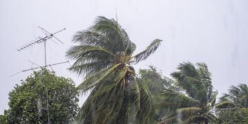
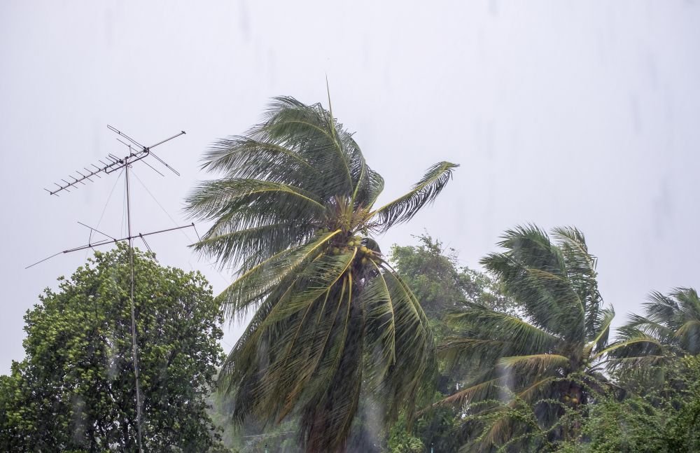
According to the Bureau of Meteorology (BOM), a powerful weather system named Tropical Cyclone Narelle is currently moving through the Coral Sea toward the Queensland coast. As of Wednesday afternoon, March 18, 2026, the cyclone has reached Category 3 intensity.
However, experts are warning that the storm is likely to grow even stronger. As reported by the ABC, the system is forecast to reach Category 4 or even Category 5 strength—the most severe level possible—before it crosses the coast on Friday morning.
Queensland Premier David Crisafulli has described this as potentially the “biggest system in living memory” for the region. At The Australian Canvas, we believe in the resilience of our northern communities, but this is a time for serious preparation and looking out for one another.
Where and When Will it Hit?
As reported by The Guardian Australia, the cyclone is expected to make landfall between Lockhart River and Port Douglas. Current tracking maps suggest the center of the storm may pass near the community of Coen.
- Thursday, March 19: Damaging winds and heavy rain are expected to begin hitting the coast.
- Friday, March 20: The “eye” or center of the cyclone is expected to cross the coastline in the morning.
After hitting the coast, the storm is forecast to move across the Cape York Peninsula toward the Gulf of Carpentaria. Even after it crosses land, it will likely bring very heavy rain to inland areas like Weipa and Kowanyama.
Understanding the Risks (Plain English)
For our friends in the CALD (Culturally and Linguistically Diverse) communities, it is important to understand what the different “Categories” mean and what the specific dangers are:
- Destructive Winds: According to the BOM, wind gusts could reach over 250 kilometers per hour if the storm reaches Category 5. As reported by the State Disaster Co-ordinator, these winds are strong enough to tear roofs off houses and turn small objects into dangerous “missiles.”
- Heavy Rainfall: The region is already very wet from previous floods. Narelle could dump another 450mm of rain in just 24 hours. This will lead to fast-moving “flash flooding” in creeks and rivers.
- Storm Tide: As reported by the BOM, the cyclone will push a large amount of seawater onto the land. This is called a “storm tide.” It can cause flooding in low-lying coastal areas, even if those areas aren’t raining.
Preparation: What is Being Done?
Our government and emergency services are working hard to ensure everyone is safe. According to reports from the Queensland Fire Department, extra swiftwater rescue teams and paramedics have already been sent to the Far North.
- Evacuations: As reported by the ABC, people in low-lying areas like Port Stewart have already begun moving to safer ground in Cooktown. Tourists on Lizard Island have also been evacuated.
- Disaster Support: The Federal and State governments have announced a $107 million support package to help communities prepare for and recover from the impacts of this storm.
- Emergency Alerts: Many people in the “Watch Zone” received text messages on Wednesday morning. According to the Lockhart River Local Disaster Management Group, these messages are a signal to “Act Now.”
Safety Tips: How to Protect Your Family
At The Australian Canvas, we want to ensure every household is ready. Here are the most important steps you can take today, explained in simple terms:
- Secure Your Yard: Put away loose items like outdoor chairs, toys, and tools. If the wind picks them up, they can break windows.
- Prepare an “Emergency Kit”: This should include enough water for three days, non-perishable food (like cans), a torch (flashlight) with extra batteries, a first-aid kit, and any important medicines.
- Stay Inside: Once the storm begins, do not go outside. Even if the wind seems to stop, you might just be in the “eye” of the storm—the wind will start again very quickly from the opposite direction.
- Don’t Drive in Floodwater: As the saying goes, “If it’s flooded, forget it.” Most deaths in cyclones happen because people try to drive or walk through moving water.
- Check on Neighbors: If you have neighbors who are elderly or who don’t speak English well, please check if they have heard the warnings. Community Storytelling and connection save lives.
The “Shared Table” of Resilience
This is the third major weather event to hit the Far North in just two months. We know that many families are tired and stressed. However, the spirit of the Far North is one of Inclusivity and Strength.
Whether you are a First Nations traditional owner in the Cape, a long-time local in Cooktown, or a new migrant working in the tourism industry in Port Douglas, we are all in this together. We have weathered these storms before by staying calm, following instructions, and helping each other.
Looking Ahead
Once the storm passes, the focus will turn to recovery. We will be tracking the government’s response to ensure that support reaches every corner of the Far North, especially our remote and multicultural communities.
For now, the most important thing is to stay informed. Keep your radio tuned to the local station, check the BOM website, and follow the advice of your local council’s “Disaster Dashboard.”
Authentic Sources & Reports (March 18, 2026):
- Bureau of Meteorology (BOM): Tropical Cyclone Advice Number 3, Issued at 4:50 pm EST (March 18, 2026).
- ABC News: “Cyclone Narelle likely to be category five at landfall in Qld” (March 18, 2026).
- The Guardian Australia: “Queensland premier warns far north Queensland cyclone could be biggest in living memory” (March 18, 2026).
- Lockhart River Local Disaster Management Group: Emergency Alert – Watch and Act (March 18, 2026).
- Queensland Government: Disaster Support Package Announcement (March 18, 2026).