


The Living Library
For more than 65,000 years, the Australian continent has been mapped through “Songlines”—sophisticated oral systems that weave together geography, kinship, law, and ecology. To the uninitiated, the Australian outback may appear as a vast wilderness; to the Traditional Custodians, it is a living library. Every ridge, waterhole, and rock formation is a mnemonic peg for a story that dictates how the land must be managed.

However, as the generation of Elders who hold these complete oral maps grows older, a new challenge has emerged: how to ensure this knowledge survives in a rapidly changing digital world. The answer is not found in dusty archives, but in the “Digital Songline”—the integration of ancient wisdom with space-age technology.
Cultural Sovereignty and Data
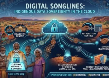
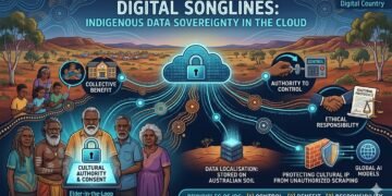
The movement toward digital mapping is an act of “Indigenous Data Sovereignty.” Historically, information about First Nations people was collected by outside anthropologists and government agencies, often without consent or proper context. Today, communities are reclaiming that narrative.
Through initiatives like the Indigenous Mapping Workshop (IMW) Australia, Rangers and Elders are using Google Earth Engine, QGIS, and drone technology to create high-definition maps of their ancestral lands. In the Kimberley region, for example, Wunambal Gaambera Traditional Custodians use the “Uunguu Ranger” program to monitor “Healthy Country” targets. By layering satellite data over traditional Dreaming tracks, they can track the health of specific species or the impact of feral animals with surgical precision.+1
This is not merely about conservation; it is about law. When a community can present a digital map that proves their continuous spiritual and physical connection to a specific tract of land, it becomes a powerful legal tool in Native Title claims and heritage protection disputes.
The Science of Caring for Country
The environmental significance of these digital Songlines cannot be overstated. Traditional ecological knowledge (TEK) is increasingly recognized as a superior method for managing the Australian landscape, particularly concerning fire.
“Cultural Burning”—the practice of using low-intensity, “cool” fires to clear undergrowth—prevents the catastrophic mega-fires that have devastated Australia in recent years. By using GPS to track these burns, Rangers can demonstrate to state fire authorities and carbon-credit markets the efficacy of their methods. In 2024 and 2025, carbon abatement programs led by First Nations groups in Northern Australia successfully prevented thousands of tonnes of CO2 from entering the atmosphere. This is the “Environmental Thread” of our national canvas: a marriage of ancient fire-stick farming and modern atmospheric science.
Challenges and Ethical Protocols
The digitization of sacred knowledge is not without risk. Under Indigenous Cultural and Intellectual Property (ICIP) rights, certain information is “Secret/Sacred”—it is not for public consumption. Therefore, the technology must be “walled.”
Software developers are now working with communities to create “tiered access” databases. A young person in the community might have access to general stories, while only a Senior Law Man or Woman holds the digital “key” to sensitive ceremonial data. This ensures that technology respects traditional hierarchy rather than dismantling it.
A Future Built on Truth
As Australia moves toward a more profound understanding of its shared history, the Digital Songline stands as a testament to resilience. It offers a blueprint for how a modern nation can honor its oldest roots while embracing its technological future.
By supporting these community-led initiatives, the broader Australian public gains a deeper appreciation for the land they call home. It moves the national conversation from one of “dispossession” to one of “continuity.” The canvas is being repainted, and for the first time in centuries, the original artists are holding the brush—and the mouse.
Verified Sources and Links
- AIATSIS (Australian Institute of Aboriginal and Torres Strait Islander Studies): For foundational research on Songlines and Cultural Heritage.
- Indigenous Mapping Workshop Australia: Case studies on the use of Google Earth and GIS in community mapping.
- Wunambal Gaambera Aboriginal Corporation: Details on the “Uunguu Ranger” program and Healthy Country Plans.
- National Indigenous Australians Agency (NIAA): Data on Indigenous Protected Areas (IPAs) and Ranger programs.
- Terrestrial Ecosystem Research Network (TERN): On the integration of Western science and Traditional Ecological Knowledge.